How Do Hurricanes Form and Why Are They Getting Stronger
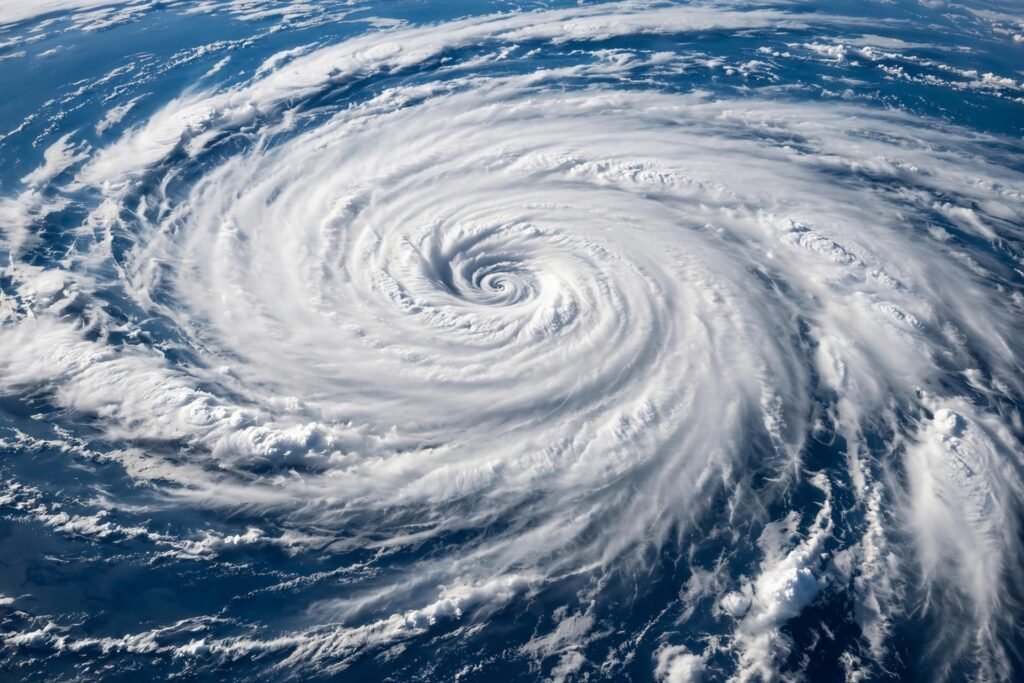
Hurricane Katrina (2005), Harvey (2017), Maria (2017), Ian (2022), Helene (2024) — the names accumulate, and the damages escalate into the hundreds of billions. Americans increasingly sense that hurricanes are getting worse, and the science largely confirms the intuition — but the ways they are changing are more specific and more interesting than “stronger storms.” Understanding how hurricanes form reveals exactly which knobs climate change is turning, and why the future looks different from the past in precise, predictable ways.
How Hurricanes Form: The Recipe
Hurricanes (called typhoons in the Northwest Pacific and cyclones in the South Pacific and Indian Ocean — same phenomenon, different regional names) require a specific set of ingredients that only coincide in certain ocean regions during certain seasons:
Ingredient 1: Warm ocean water (at least 26.5°C / 80°F)
This is the fuel. Warm water evaporates readily, and the water vapor carries latent heat — enormous energy stored in the phase change from liquid to gas. A mature hurricane releases heat energy equivalent to a 10-megaton nuclear bomb exploding every 20 minutes, all of it ultimately sourced from warm ocean water. The 26.5°C threshold extends roughly 50 meters deep — a shallow warm puddle will not sustain a storm; the heat content must have depth.
Ingredient 2: Moist, unstable atmosphere
Rising warm, moist air must be able to keep rising — which requires the atmosphere above to be cooler and the mid-levels to be humid. Dry air intruding into the developing circulation chokes it (this “dry air entrainment” is why many tropical disturbances never develop). The storm is a heat engine, and like any engine, it needs both fuel intake and exhaust.
Ingredient 3: Low vertical wind shear
Winds at different altitudes must blow at similar speeds and directions. Strong shear — winds changing rapidly with height — tilts and tears apart the developing vortex, ventilating its core heat away. This is why hurricanes rarely form near the equator’s strong upper winds or in regions of persistent shear, and why a sudden shear increase can kill a major hurricane in a day.
Ingredient 4: Pre-existing disturbance and Coriolis force
Hurricanes spin up from tropical waves — westward-moving disturbances rolling off Africa — given a seed rotation. The Coriolis force (Earth’s rotation effect) organizes the spin, which is why hurricanes essentially never form within about 5° of the equator, where Coriolis is too weak. Once organized, the feedback loop intensifies: stronger winds → more evaporation → more latent heat → stronger rising air → lower central pressure → stronger winds.
The National Hurricane Center monitors these ingredients in real time during hurricane season (June 1–November 30 in the Atlantic), and its forecasting has improved dramatically — track forecasts are vastly better than decades ago, though intensity forecasting remains the harder problem.
Why They Are Getting Stronger: The Climate Knobs
Climate change does not create hurricanes from nothing — it modifies the recipe’s ingredients. Here is what the science shows, with appropriate confidence levels:
Warmer oceans → more fuel (high confidence)
Atlantic sea surface temperatures have risen significantly, expanding both the area above the 26.5°C threshold and the season during which it is exceeded. More fuel availability directly enables higher peak intensities — the thermodynamic speed limit for hurricanes (potential intensity theory) rises with ocean temperature. The proportion of major hurricanes (Category 3+) has increased globally, consistent with this mechanism.
More rainfall (very high confidence)
A warmer atmosphere holds about 7 percent more moisture per degree Celsius (Clausius-Clapeyron relation) — basic physics, not model speculation. Hurricane Harvey’s record rainfall (60+ inches near Houston) was amplified by this effect; attribution studies found climate change increased its precipitation by roughly 15–20 percent. Rainfall is now the leading hurricane killer in the US (via inland flooding), surpassing storm surge and wind.
Rapid intensification increasing (growing evidence)
Storms jumping multiple categories in 24 hours — like Harvey, Maria, Michael, and Ian did — are becoming more common, and this is the most dangerous trend for preparedness: forecasts and evacuations assume gradual strengthening, and rapid intensifiers compress warning timelines. Warmer deep ocean heat content is the suspected driver.
Slower movement → longer punishment (emerging evidence)
Some studies find tropical cyclones moving more slowly, prolonging rainfall and wind exposure over affected areas. Harvey’s stall over Houston (dropping unprecedented rain for days) exemplifies the damage multiplier of slow motion combined with enhanced rainfall.
What is NOT clearly changing
The total number of hurricanes shows no clear global trend — and may even decrease slightly, as the same warming that fuels individual storms can increase the shear that suppresses formation. Frequency is not the story; character is. Fewer total storms, but a higher fraction becoming monsters, carrying more water, intensifying faster, and moving slower.
What This Means for Americans Practically
The changing character of hurricanes demands updated preparedness thinking: flood risk now rivals wind as the primary threat — check flood maps and insurance even outside designated flood zones (a large share of Harvey’s flooded homes were outside mapped high-risk areas); rapid intensification means evacuation decisions may need to come earlier, with less certainty; inland areas face growing risk as slow-moving storms carry destructive rainfall far from the coast (Helene’s Appalachian devastation rewrote assumptions about who is safe); and building codes matter enormously — modern codes dramatically reduce damage, making having the right tools for home repairs and maintaining your home’s storm readiness a genuine safety investment, not just property protection.
Staying informed is the foundation: the NOAA hurricane resources provide forecasts, preparedness guides, and real-time tracking. The science will keep refining the picture, but the direction is clear — the storms of the coming decades will be wetter, potentially more intense, and less predictable in their strengthening. Preparedness thinking needs to update accordingly.
The Bottom Line
Hurricanes form when warm deep ocean water, moist unstable air, low wind shear, and a seed disturbance coincide — a heat engine converting ocean warmth into destructive power. Climate change is turning specific knobs: more fuel for higher peak intensities, ~7 percent more atmospheric moisture per degree driving heavier rainfall, increasing rapid intensification compressing warning times, and possibly slower storm motion prolonging punishment. The number of storms is not clearly rising — but their character is changing in ways that demand new respect from everyone in harm’s way.
When a Storm Is Coming: Practical Preparation
Understanding hurricanes should end in action, not just awe. If you live in a storm-prone region, preparation beats reaction: know your evacuation zone, keep a go-bag ready during hurricane season, and protect your home’s weakest points — windows and doors — before warnings arrive. Techniques for weatherproofing windows against storms range from simple film and caulking to proper storm shutters, and even renters can take meaningful steps. Photograph your belongings for insurance, charge backup batteries, and never underestimate storm surge — water, not wind, causes most hurricane fatalities. The science tells you the threat is growing; the preparation tells you it does not have to be a disaster.
Frequently Asked Questions
What is the difference between a hurricane, typhoon, and cyclone?
They’re the same phenomenon with regional names: hurricanes (Atlantic/Northeast Pacific), typhoons (Northwest Pacific), cyclones (South Pacific/Indian Ocean). The physics is identical.
Are hurricanes actually getting stronger?
The proportion of major hurricanes (Category 3+) is increasing, peak intensities are rising with warmer oceans, rainfall is heavier, and rapid intensification is more common. Total storm counts show no clear trend — it’s the character, not the number, that’s changing.
Why is hurricane rainfall increasing?
Warmer air holds ~7% more moisture per degree Celsius (basic physics). This directly amplifies hurricane precipitation — Harvey’s record rainfall was increased ~15-20% by climate change, per attribution studies.
What is rapid intensification?
A storm strengthening dramatically (35+ mph wind increase) in 24 hours. It’s becoming more common and is especially dangerous because it compresses evacuation and preparation timelines.
When is Atlantic hurricane season?
June 1 through November 30, with peak activity typically mid-August through October. Warmer oceans are extending the effective season at both ends.